top of page

[Day 7] 2024.11.30
Gradually weakening snow clouds.

Southwesterly winds
& high pressure
colder than average
No precipitation
1. Pressure system
[ 500hPa weather chart 2024-11-30 09KST ]
[ 500hPa weather chart 2024-11-30 21KST ]

Although the trough has cleared out, the height contours remain tightly packed, signaling the passage of a strong wind band. Temperatures aloft linger between –25 °C and –20 °C, giving the atmosphere a touch of instability.
[ Surface weather chart 2024-11-30 09KST ]
[ Surface weather chart 2024-11-30 21KST ]

Cold, continental air keeps streaming south on brisk northwesterlies. Showers (or snow showers) are possible along parts of the West and East Coasts during the morning, but by afternoon a building ridge brings comparatively clear and dry conditions across much of the country.
2. Clouds & Precipitation
[ Water Vapor imagery 2024-11-30 09KST ]
[ Water Vapor imagery 2024-11-30 21KST ]

In the morning, upper-level moisture and upward motion on the front side of a trough supported cloud development over Korea. By evening, the trough had shifted eastward, and Korea was under dry, subsiding air, leading to cloud dissipation.
[ 2024-11-30 09KST ]
[ 2024-11-30 21KST ]
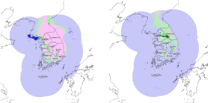
In the morning, snow and rain occurred across the central region, particularly Seoul, Gyeonggi, and Chungcheong. By evening, precipitation weakened and mostly ended as the trough exited and the atmosphere stabilized.
3. Temperature


This is the Skew-T log P diagram for 09 KST on the 30th.
Using the moist adiabat, the maximum temperature on the 30th is predicted to be around 4°C.
This is the Skew-T log P diagram for 03 KST on the 31st.
Using the moist adiabat, the minimum temperature on the 31st is predicted to be around 6°C.
4. Summary
- Temperatures will gradually rise due to southwesterly winds.
- Although no precipitation is expected, caution is advised for remaining icy roads and black ice.
bottom of page