
[Day 3] 2024.11.26
Rain in the morning due to low pressure.
First snow at night.

Rain
hotter than usual
First snow at night
1. Pressure system
[ 500hPa weather chart 2024-11-26 09KST ]
[ 500hPa weather chart 2024-11-26 21KST ]

Over eastern China, extremely cold air with temperatures below -40°C is circulating, contributing to the formation of a low-pressure system. High-pressure systems have developed on both sides of this low, and a ridge of high pressure to its east is blocking the system’s eastward movement. The ridge over the Sea of Okhotsk is preventing the low from advancing further east, causing it to begin drifting southward toward the Korean Peninsula. We can see that this cut-off low is gradually moving closer to the region, with cold air funneling down between the surrounding high-pressure ridges like a valley.
[ 850hPa weather chart 2024-11-26 09KST ]
[ 850hPa weather chart 2024-11-26 21KST ]

Throughout the day on the 26th, both morning and afternoon weather charts show significant moisture present in the 850 hPa layer over the entire Korean Peninsula. A low-pressure system is also evident to the north of the Peninsula at this level.
[ Surface weather chart 2024-11-26 09KST ]
[ Surface weather chart 2024-11-26 21KST ]

Korea is currently situated between a strong high-pressure system to the west and a developing low to the north, creating a steep pressure gradient and resulting in strong winds. The atmosphere is unstable not only in the upper layers but also at the surface due to the influence of the approaching low.
2. Clouds & Precipitation
[ Water Vapor imagery 2024-11-26 09KST ]
[ Water Vapor imagery 2024-11-26 21KST ]

On the morning of November 26, a trough of atmospheric pressure passed over the Korean Peninsula, and clouds and precipitation were formed due to the concentration of water vapor and active rising currents across the country. In the afternoon, as the trough moved rapidly eastward, the Korean Peninsula began to be affected by downward air currents and dry air, As a result, the clouds gradually disappeared and precipitation weakened.
[ 2024-11-26 09KST ]
[ 2024-11-26 21KST ]
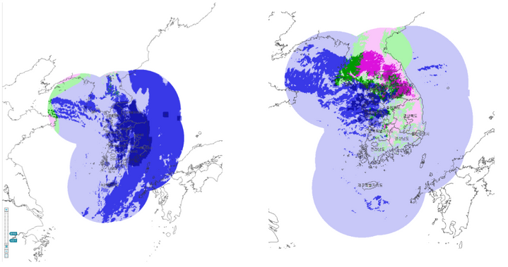
Widespread rain fell across the country on the morning of November 26, with snow or sleet observed in some northwestern regions. As the afternoon progressed, the snow and mixed precipitation area expanded around the central inland and the mountains of Gangwon-do, where the temperature was low, and the precipitation center also moved northeast. This was shown to be consistent with the passage of upper atmospheric troughs and the enhancement of updrafts seen in steam satellite images.
3. Temperature
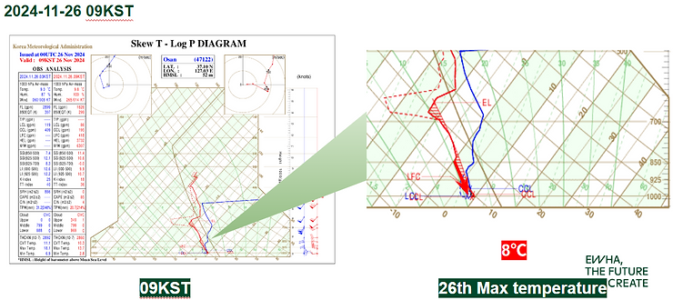

It's 09 KST skew-T log P diagram on the 26th. It's raining on the 25th. The maximum temperature of 26th obtained using moist adiabat is predicted to be 8°C.
It's 03 KST skew-T log P diagram on the 27th. It predicts the lowest temperature on the 26th using moist adiabatic lines. The minimum temperature on the 27th is predicted to be -1°C.
4. Summary
- The rain will spread across the country, and gradually stop from day to afternoon
- colder weather than yesterday
- First snow from the night