
[Day 4] 2024.11.27
Special warning for heavy snow in Seoul takes effect.

high sea level temperature
colder than usual
A special snow advisory
1. Pressure system
[ 500hPa weather chart 2024-11-27 09KST ]
[ 500hPa weather chart 2024-11-27 21KST ]

A strong blocking high over the Sea of Okhotsk has led to the formation of a cut-off low in the upper atmosphere north of the Korean Peninsula. This high is effectively halting the eastward flow of the jet stream, trapping the cut-off low and forcing it to descend toward the Korean Peninsula at the 500 hPa level. Since this cut-off low is carrying cold Arctic air, its core remains extremely cold, creating highly unstable atmospheric conditions.
[ 850hPa weather chart 2024-11-27 09KST ]
[ 850hPa weather chart 2024-11-27 21KST ]

The difference between temperature and dew point is within 3°C, indicating a high level of atmospheric moisture. As the cut-off low continues its counterclockwise rotation, it pulls down cold air from the north. Similar to the morning, in the afternoon, the entire country remains very moist, with a dew point depression of less than 3°C, and the influence of the low continues.
[ Surface weather chart 2024-11-27 09KST ]
[ Surface weather chart 2024-11-27 21KST ]
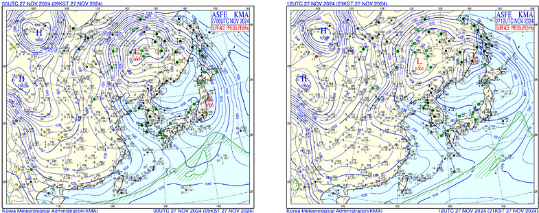
Snow is falling due to the presence of the upper-level low. In the Seoul area, where surface temperatures are below 0°C, the precipitation is falling as snow.

Over northern parts of the Korean Peninsula, the Total Totals Index (TTI) is observed in the range of 45 to 50, indicating weak atmospheric instability.
Indices such as the K Index (KI), typically used to diagnose heavy rainfall associated with moist maritime air masses in summer, and the Showalter Stability Index (SSI), which is useful for predicting convective activity and thunderstorms under calm, clear conditions with rapid surface warming, are not suitable for diagnosing precipitation driven by low-pressure systems.
In contrast, the Cross Totals Index (CT) is more effective when the region is under the influence of a cut-off low with a cold core at 500 hPa or a well-developed upper-level trough. However, since CT does not account for lower-level temperatures, it is complemented by the TT Index. The Total Totals Index incorporates the temperature difference between 850 hPa and 500 hPa, allowing for a better assessment of mid-to-lower atmospheric instability and helping to predict both the extent and intensity of potential thunderstorms.
For this reason, the TT Index was selected as the primary instability index for this analysis.
2. Clouds & Precipitation
[ Water Vapor imagery 2024-11-27 09KST ]
[ Water Vapor imagery 2024-11-27 21KST ]

On the morning of November 27, precipitation over Korea gradually weakened as the region moved into the rear of the upper-level trough, and water vapor shifted eastward over the East Sea and Japan.
By the evening, the trough had fully exited the region, bringing dry air and dominant subsidence over the Korean Peninsula, which led to rapid cloud dissipation. As a result, most areas turned clearer throughout the day, and temperatures likely dropped due to the inflow of cold northwesterly air.
[ 2024-11-27 09KST ]
[ 2024-11-27 21KST ]

On the morning of November 27, mixed precipitation conditions with snow and rain appeared in most parts of the country at the same time, and it mainly rained in the south of Chungcheong. As the temperature decreased in the afternoon, the form of precipitation gradually changed to snow, and strong snow was concentrated in Gangwon-do and the northern part of the metropolitan area.
This is interpreted as the influence of cold air from the northwest and the air pressure trough posterior updrafts.
3. Temperature

It is 09 KST skew-T log P diagram on the 27th. The maximum temperature of 27th obtained using moist adiabat is predicted to be 2°C.

It's 03 kst skew-t on the 28th. It's snowing, so we predict the lowest temperature on the 28th using moist adiabat. The minimum temperature on the 28th is predicted to be -1°C.
4. Summary
- continuous snowy weather
- Be aware of accidents caused by snow because the temperature has decreased dramatically